Rivers, Lakes and Water Systems
Puerto Rico's hydrography includes a complex network of rivers, reservoirs, wetlands, lagoons, and coastal waters that play an essential role in the island's environment and water supply.
The island's central mountain range, La Cordillera Central, divides Puerto Rico into northern and southern watersheds. Rivers originating in these mountains flow either toward the Atlantic Ocean in the north or the Caribbean Sea in the south.
Although Puerto Rico is relatively small and does not have long rivers or natural lakes, the island contains more than 1,200 bodies of water, including approximately 50 rivers, numerous reservoirs, and several coastal lagoons that support wildlife and recreation.
Overview
Why Puerto Rico Is So Rich in Water
For an island measuring just 100 miles long by 35 miles wide, Puerto Rico has an extraordinary abundance of freshwater. More than 1,300 rivers and streams crisscross the island, creating waterfalls, natural swimming holes, reservoirs, wetlands, and fertile valleys that have sustained communities for centuries.
Several unique geographic and climatic features work together to make Puerto Rico one of the most water-rich islands in the Caribbean.
The Cordillera Central
Running east to west through the heart of Puerto Rico, the Cordillera Central serves as the island's mountainous backbone. Most rivers begin in these high elevations before flowing toward either the Atlantic Ocean to the north or the Caribbean Sea to the south.
Because the mountains divide the island, many rivers are relatively short but descend rapidly, creating scenic waterfalls, rapids, and dramatic river valleys.
Trade Winds and Tropical Rainfall
Moist trade winds blowing in from the Atlantic Ocean rise as they encounter Puerto Rico's mountains. As the air cools, it releases large amounts of rainfall, especially across the northern slopes and El Yunque National Forest.
Some parts of El Yunque receive over 150 inches (3,800 mm) of rain annually, feeding countless rivers and streams throughout the year.
The Karst Region
Puerto Rico's northern limestone, or karst, region acts like a giant natural sponge. Rainwater filters through sinkholes, caves, and underground channels before emerging as springs that feed rivers and wetlands.
This unique landscape is also home to impressive cave systems, including the Río Camuy Cave Park, one of the world's largest cave networks.
Watersheds
The island is divided into numerous watersheds, or drainage basins, where rainfall naturally flows toward a common river, lake, or reservoir.
These watersheds supply drinking water, irrigate farmland, generate hydroelectric power, and support countless ecosystems across Puerto Rico.
Why It Matters
Puerto Rico's rivers do far more than shape the landscape. They provide fresh drinking water, support agriculture, nourish rainforests and wetlands, generate electricity, and create some of the island's most spectacular outdoor destinations.
From hidden mountain pools to expansive reservoirs and coastal estuaries, water has played a central role in Puerto Rico's history, economy, and natural beauty.
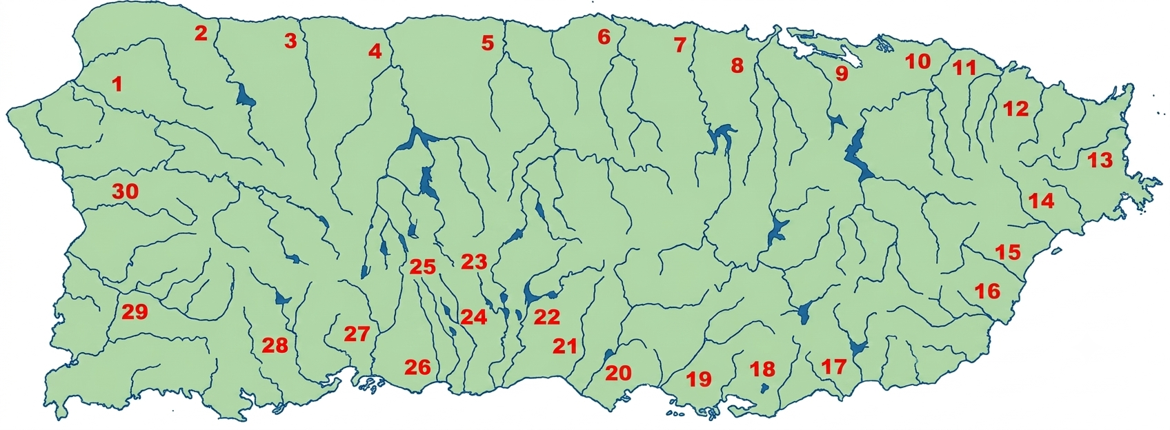
Rivers of Puerto Rico
Puerto Rico's rivers vary greatly depending on their location and rainfall patterns.
Northern Rivers
Fed by abundant rainfall and the island's limestone mountains, northern rivers are generally the longest and most powerful in Puerto Rico. They carve deep valleys through the karst region before emptying into the Atlantic Ocean. Many support reservoirs, underground cave systems, and fertile agricultural lands.
Important northern rivers include:
- Río Grande de Arecibo – Puerto Rico's longest river, flowing through the northern karst region.
- Río La Plata – One of the island's longest rivers, stretching from the Cordillera Central to the Atlantic Ocean.
- Río Cibuco – A major northern river that supports agriculture and local ecosystems.
- Río Loíza – Puerto Rico's largest river by water volume and a vital source of fresh water.
- Río Bayamón – Flows through the San Juan metropolitan area, supporting urban communities and recreation.
- Río Grande de Loíza - Puerto Rico's largest river by water volume and an important source of drinking water.
- Río Grande de Arecibo - The island's longest river, flowing through the heart of the northern karst region.
- Río Camuy - Famous for carving the spectacular Río Camuy Cave Park, one of the world's largest cave systems.
- Río Manatí - Known for its scenic canyons, waterfalls, and limestone landscapes.
- Río Espíritu Santo - One of Puerto Rico's cleanest rivers, flowing through the lush rainforests of Río Grande.
Several major rivers also flow westward toward the Mona Passage, including Río Grande de Añasco, Río Guanajibo, and Río Culebrinas.
Many northern rivers maintain perennial (year-round) flow.
Southern Rivers
Southern Puerto Rico receives significantly less rainfall, making its rivers shorter, narrower, and often seasonal. Although many originate in the Cordillera Central, they quickly descend toward the Caribbean Sea and play an important role in irrigation, reservoirs, and supplying water to the island's drier southern communities.
Many southern rivers are seasonal, occasionally drying out before filling rapidly during heavy rains.
- Río Portugués – One of the few perennial rivers in southern Puerto Rico, flowing year-round.
- Río Loco – Known for its seasonal flow and importance to southern irrigation.
- Río Coamo – Flows past the island's famous natural hot springs..
- Río Grande de Patillas – A major river of southeastern Puerto Rico and an important source of fresh water.
- Río Jacaguas - One of Puerto Rico's longest southern rivers, supporting agriculture and irrigation.
- Río Yauco - Flows through Puerto Rico's historic coffee-growing region before reaching the Caribbean Sea.
- Río Tallaboa - A short but important river that supplies water to nearby communities and ecosystems.
- Río Guayanilla - Flows from the Cordillera Central to Guayanilla Bay, supporting agriculture and wildlife.
- Río Descalabrado - A seasonal river that helps irrigate the fertile plains of Santa Isabel.
- Río Guanajibo - The longest river in western Puerto Rico, known for its fertile valley and agricultural importance.
Subterranean rivers are also common in the island's karst region, particularly in northwestern Puerto Rico.
Eastern Rivers
The eastern region receives some of the highest rainfall on the island thanks to El Yunque National Forest. Its rivers flow through lush rainforests, waterfalls, and protected natural areas before reaching the Atlantic Ocean or Caribbean Sea. Many are known for crystal-clear waters, recreational opportunities, and rich biodiversity.
- Río Espíritu Santo - One of Puerto Rico's cleanest rivers, flowing through the lush rainforests of Río Grande.
- Río Mameyes - The only river in Puerto Rico protected under the National Wild and Scenic Rivers System.
- Río Fajardo - A scenic mountain river that flows through El Yunque's eastern foothills.
- Río Sabana - Known for its crystal-clear waters and picturesque waterfalls.
- Río Blanco - A rainforest river feeding waterfalls, natural pools, and hydroelectric facilities.
- Río Antón Ruiz - Supports agriculture and wetlands along Puerto Rico's eastern coastal plain.
- Río Humacao - Flows through the Humacao Nature Reserve before reaching the Caribbean Sea.
- Río Gurabo - A major tributary of Río Grande de Loíza, supporting eastern communities and agriculture.
Western Rivers
Western Puerto Rico is characterized by scenic mountain rivers that wind through forests, coffee-growing regions, and fertile valleys before reaching the Mona Passage. These rivers support agriculture, recreation, and several important reservoirs while offering beautiful landscapes throughout the region.
- Río Guanajibo - The longest river in western Puerto Rico, known for its fertile valley and agricultural importance.
- Río Culebrinas - A scenic river flowing through forests and valleys before reaching the Mona Passage.
- Río Grande de Añasco - One of western Puerto Rico's largest rivers, draining the island's coffee-growing mountains.
- Río Yagüez - Flows through the city of Mayagüez and into Mayagüez Bay.
- Río Guajataca - Feeds Guajataca Lake and winds through Puerto Rico's limestone region.
- Río Rosario - A mountain river known for its clear waters and lush surroundings.
- Río Guacio - A coastal river supporting wetlands and wildlife in northwestern Puerto Rico.
- Río Hondo - A small western river flowing through fertile valleys and agricultural lands.
Central Rivers
The mountains of the Cordillera Central are the birthplace of many of Puerto Rico's rivers. Although most eventually flow north or south, the central region contains countless headwaters, mountain streams, waterfalls, and reservoirs that supply fresh water to much of the island. This region offers some of Puerto Rico's most scenic river landscapes and outdoor adventures.
Notable rivers and headwaters include:
- Río Grande de Arecibo - Begins in the Cordillera Central before becoming Puerto Rico's longest river.
- Río La Plata - Originates in the central mountains and flows north to the Atlantic Ocean.
- Río Jacaguas - Rises in the Cordillera Central before crossing the island's southern plains.
- Río Grande de Manatí - Forms in the central highlands and flows through dramatic canyons and limestone valleys.
- Río Cibuco - Begins in the mountains before winding through fertile northern farmland.
- Río Orocovis - A mountain river known for its scenic landscapes and abundant rainfall.
- Río Toro Negro - Flows through Toro Negro State Forest, one of Puerto Rico's most rugged mountain regions.
- Río Limón - A picturesque mountain stream surrounded by forests and steep valleys.
Best Known For
- Northern: Longest rivers, karst landscapes, caves, reservoirs
- Southern: Seasonal rivers, irrigation, reservoirs
- Eastern: Rainforest, waterfalls, swimming holes
- Western: Coffee region, scenic valleys, fishing
- Central: Headwaters, mountain streams, hiking
- Culebrines
- Guajataca
- Camuy
- Grande de Arecibo
- Grande de Manatí
- Cibuco
- La Plata
- Bayamón
- Piedras
- Grande de Loiza
- Herrera
- Espiritu Santo
- Fajardo
- Blanco
- Humacao
- Guayanés
- Grande de Patilla
- Guamani
- Salinas
- Coamo
- Descalabrado
- Jacaguas
- Inabón
- Bucana
- ortugués
- Matilde
- Tallaboa
- Yauco
- Guanajibo
- Grande de Añasco
| Longest Rivers (kms.) | |||
| La Plata | 48 | Guajataca | 27 |
| Grande de Añasco | 43 | Coamo | 27 |
| Grande de Loiza | 41 | Camuy | 26 |
| Manati | 40 | Jacaguas | 26 |
| Arecibo | 38 | Yauco | 24 |
| Bayamon | 34 | Salinas | 21 |
| Culebrinas | 33 | Guayanés | 18 |
| Guanajibo | 30 | Tallaboa | 16 |
| Cibuco | 29 | ||
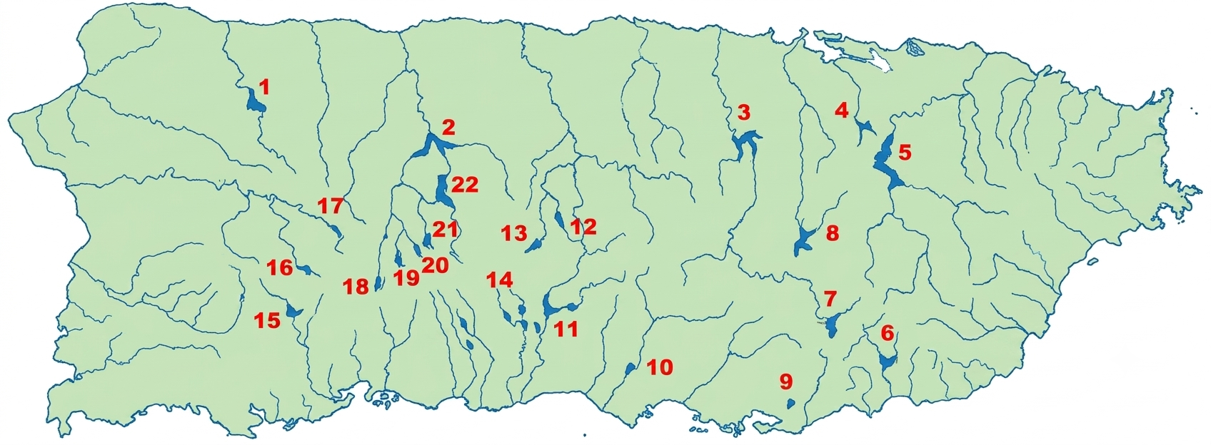
Lakes and Reservoirs
Puerto Rico does not have natural lakes. Instead, the island has artificial reservoirs created by dams to supply drinking water, irrigation, and hydroelectric power.
Major reservoirs include:
- Lago La Plata – one of the island's largest reservoirs, supplying water to San Juan
- Lago Dos Bocas – This reservoir created in 1942, adjacent to the Rio Abajo Forest, located 12 miles (19km) south of Arecibo. a scenic lake popular for boat tours. Free ferry ride across the lake are available
- Lago Carraízo – a primary water source for the metropolitan area, Puerto Rico's largest lake, located on route 175 or 739
- Lago Guajataca – provides drinking water to northwestern Puerto Rico
- Lago Lucchetti – Located in Lares, this lake is important for irrigation and hydroelectric power
Although hydroelectric facilities exist, they provide less than 1% of Puerto Rico's electricity production.
- Guajataca, Camuy
- Dos Bocas
- Comerio
- Curias
- Loiza
- Patillas
- Carite, Guayama
- Cidra
- Guamani
- Coamo
- Toa Vaca, Villalba
- Matrullas
- Guineo
- Guayabal, Juana Diaz
- Yauco
- Prieto
- Yahuecas
- Garzas, Adjuntas
- Adjuntas
- Pellejas
- Vivi
- Caonillas, Utuado
Wetlands and Lagoons
Puerto Rico also contains several important coastal lagoons and wetlands, which support marine ecosystems and wildlife habitats.
Important lagoons include:
- Laguna del Condado (San Juan) – a popular spot for kayaking and paddleboarding
- Laguna San José (San Juan) – a significant mangrove ecosystem
- Laguna Piñones & Laguna Torrecillas (Carolina) – both located in a protected coastal area with rich biodiversity
- Laguna Joyuda (Cabo Rojo) – the largest coastal lagoon in Puerto Rico, known for its fishing industry
- Laguna Tortuguero (Manatí) – the largest freshwater lagoon on the island, home to many endangered species
Top Water Experiences in Puerto Rico
Puerto Rico's rivers, lakes, and waterways offer much more than beautiful scenery. From rainforest waterfalls and underground rivers to mountain reservoirs and glowing lagoons, these experiences showcase some of the island's most remarkable natural attractions.
Swim Beneath Rainforest Waterfalls
Cool off in the natural pools and waterfalls of El Yunque National Forest (Río Grande), where mountain streams cascade through lush tropical rainforest.
Cruise Across Lago Dos Bocas
Take a scenic boat ride across Lago Dos Bocas (Utuado & Arecibo) and enjoy breathtaking mountain scenery before stopping at one of the lakeside restaurants accessible only by water.
Explore Río Camuy Cave Park
Discover one of the world's largest cave systems at Río Camuy Cave Park (Camuy), where underground rivers have carved spectacular limestone caverns over millions of years.
Kayak Laguna Grande
Paddle through the mangrove channels of Laguna Grande (Fajardo), home to one of Puerto Rico's famous bioluminescent bays that glows after sunset.
Walk the Mangroves of Piñones
Explore the boardwalks and coastal wetlands of Piñones (Loíza), where mangrove forests provide habitat for birds, crabs, fish, and other wildlife.
Visit Charco Azul
Photograph—or take a refreshing swim in—the crystal-clear waters of Charco Azul (Patillas), one of Puerto Rico's best-known natural swimming holes.
Fish at Lago Guajataca
Spend a relaxing morning fishing or enjoying the peaceful surroundings of Lago Guajataca (Quebradillas, Isabela & San Sebastián), one of Puerto Rico's most scenic reservoirs.
Hike Along the Río Espíritu Santo
Follow forest trails near Río Grande to experience one of Puerto Rico's most pristine rivers, surrounded by lush rainforest and abundant wildlife.
Watch Wildlife at Laguna Cartagena
Visit Laguna Cartagena National Wildlife Refuge (Lajas) to observe migratory birds, native wildlife, and one of the island's most important freshwater wetlands.
Discover Mountain Rivers in Toro Negro
Explore the streams, waterfalls, and panoramic mountain scenery of Toro Negro State Forest (Orocovis), where several of Puerto Rico's rivers begin their journey to the sea.
Why I Love Puerto Rico's Rivers
Growing up in Puerto Rico, rivers and waterfalls often felt like part of the neighborhood rather than distant wilderness. Families knew where to find the local charca, which roads crossed a river, and which swimming spots became dangerous after heavy rain. That familiarity is part of island life—but visitors should remember that currents and water levels can change very quickly.
Local Tips
Don't underestimate river currents
Heavy rain in the mountains can quickly raise river levels, even if the weather is sunny where you're standing.
Wear water shoes
Many riverbeds are rocky and slippery.
Respect private property
Some river access points cross private land.
Visit after moderate rain
Waterfalls are more impressive, but avoid visiting after storms.
Leave No Trace
Many rivers provide drinking water for nearby communities.
Why Water Is Essential to Puerto Rico
Water is one of Puerto Rico's most valuable natural resources. From the rainforests of El Yunque to the reservoirs that supply drinking water, rivers and waterways have shaped the island's landscapes, supported its communities, and sustained its ecosystems for thousands of years. Today, freshwater continues to play a vital role in everyday life, agriculture, recreation, energy production, and environmental conservation.
Drinking Water
Puerto Rico's rivers and reservoirs provide fresh drinking water to communities across the island. Major reservoirs such as Carraízo, La Plata, Dos Bocas, and Cerrillos collect rainfall from surrounding watersheds before the water is treated and distributed to homes and businesses. Protecting these watersheds helps ensure a reliable water supply for future generations.
Agriculture
Water has long been the foundation of Puerto Rico's agriculture. Rivers irrigate fertile valleys where farmers grow bananas, plantains, vegetables, citrus fruits, tropical fruits, and other crops. In the drier southern region, reservoirs and irrigation systems are especially important for supporting agriculture throughout the year.
Coffee Growing
Puerto Rico's world-famous coffee owes much of its quality to the island's abundant rainfall and mountain rivers. The cool, moist conditions of the Cordillera Central create the ideal environment for growing premium coffee beans, while nearby streams and rivers have historically supplied farms with the water needed for cultivation and processing.
Hydroelectric Power
Although hydroelectricity represents only a small portion of Puerto Rico's electricity today, several reservoirs were originally developed to generate renewable energy. These dams continue to help regulate water supplies, reduce flooding, and support communities throughout the island.
Wildlife & Biodiversity
Puerto Rico's rivers, wetlands, mangroves, and freshwater lagoons provide essential habitat for hundreds of species of birds, fish, amphibians, reptiles, and mammals. Many migratory birds depend on these ecosystems each year, while protected forests and wetlands help preserve some of the island's rarest wildlife.
Coral Reefs & Coastal Ecosystems
Healthy rivers benefit the ocean as well. Freshwater flowing into estuaries carries nutrients that support mangroves, seagrass beds, and coral reefs. These coastal ecosystems provide habitat for sea turtles, tropical fish, manatees, dolphins, and countless marine species while also protecting shorelines from erosion and storm damage.
Recreation & Tourism
Puerto Rico's waterways are among its most popular outdoor destinations. Visitors can hike to waterfalls in El Yunque National Forest, kayak through bioluminescent lagoons, explore underground rivers in Río Camuy Cave Park, fish in mountain reservoirs, or cool off in crystal-clear natural pools. These experiences offer a different side of Puerto Rico beyond its beaches.
Climate & Natural Balance
Water helps regulate Puerto Rico's climate by cooling forests, replenishing groundwater, and supporting lush vegetation across the island. Healthy watersheds reduce flooding, improve water quality, prevent soil erosion, and help ecosystems recover after hurricanes and periods of drought.
Looking Ahead
As Puerto Rico continues to grow and adapt to climate change, protecting its rivers, reservoirs, wetlands, and watersheds is more important than ever. Conservation efforts, responsible recreation, and sustainable water management help ensure these resources remain healthy for future generations while preserving many of the natural places that make Puerto Rico unique.
Plan Your Water Adventure
Whether you're hiking to a hidden waterfall in El Yunque, cruising across Lago Dos Bocas, exploring the underground chambers of Río Camuy Cave Park, or kayaking through glowing mangrove lagoons, Puerto Rico's waterways reveal a side of the island many visitors never expect. Beyond the beaches lies a landscape shaped by rivers, forests, mountains, and reservoirs—inviting you to experience Puerto Rico from a completely different perspective.
Did You Know?
El Yunque, located in Luquillo, is the only tropical forest in the United States National Forest System.
This is your comprehensive guide to La Isla del Encanto.