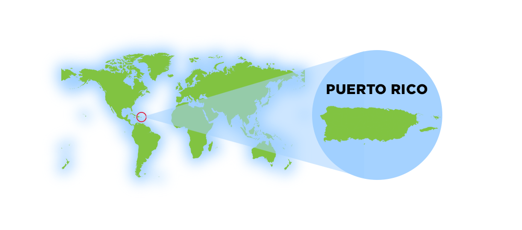
Geography of Puerto Rico
Geography shapes everything in Puerto Rico—from its lush rainforests and towering mountains to its beaches, rivers, caves, and vibrant communities. Although the island measures just 100 miles long by 35 miles wide, its remarkable diversity of landscapes and ecosystems makes it one of the Caribbean's most geographically fascinating destinations.
Overview
Location & Size
The island of Puerto Rico is a very popular tourist destination because of its location, rich history and warm atmostphere. Puerto Rico is strategically positioned in the northeastern Caribbean Sea.
Geographic Position
Coordinates
Latitude: 18° 15" N Longitude: 66° 30" W
Location
- Easternmost island of the Greater Antilles
- Between the Caribbean Sea and Atlantic Ocean
- 1,000 miles southeast of Miami, Florida
- West of the U.S. Virgin Islands
- East of Hispaniola (Dominican Republic/Haiti)
Region
North America
Subregion
Caribbean
Map References
Central America and the Caribbean
Limits
To the west by Haití and the Dominican Republic (La
Hispañola), separated by the Mona Passage ("Mona Canal"), to
the east by the Virgin Islands, to the north by the Atlantic Ocean, and to the
south by the Caribbean Sea.
Dimensions
Land Area
3,515 sq mi (9,104 sq km)
Roughly the size of Connecticut or three times the size of Rhode Island
Water Area
145 sq km
Island Measurements
- Length: 100 miles (160 km) east to west
- Width: 35 miles (56 km) north to south
- Coastline: 270 miles (435 km)
- Offshore Islands: Over 140 smaller islands
Land boundaries
0 km
Borders
Puerto Rico is under the U.S. customs jurisdiction. Borders are
open between P.R. and the U.S., allowing for free movement of people and
merchandise.
Maritime Claims
Continental shelf: 200 NM (depth)
Exclusive economic zone: 200 NM
Territorial sea: 12 NM
The island is located in the Caribbean, between the Caribbean Sea and the North Atlantic Ocean, east of the Dominican Republic, about 1,000 miles (1,600 km) southeast of Miami, Florida. Puerto Rico is one of the 28 islands in the Caribbean.
Puerto Rico is almost rectangular in shape, approximately 100 miles long by 35 miles wide and is the smallest and the most eastern island of the Greater Antilles (Cuba, Hispaniola, Jamaica and Puerto Rico).
Although, often referred an island, Puerto Rico is an archipelago formed by the main island and 143 small islands, islets and cays, including Vieques, Culebra, Culebrita, Palomino, Mona, and Monito. Vieques and Culebra are also known by some by the Spanish Virgin Islands, formerly called the Passage Islands and also known as the Puerto Rican Virgin Islands.
Its coasts measures approximately 435 km, and if the adjacent islands Vieques and Culebra are included the coast measures approximately 700 km. With an area of 3,425 square miles (9,104 sq km), Puerto Rico is the third largest island in the United States and the 82nd largest island in the world.
3rd largest island in the U.S. (after Hawaii and Kodiak Island, Alaska)
Atlantic Standard Time (AST), UTC-4 year-round (no daylight saving)
Vieques, Culebra, and Mona Island are the largest offshore territories
~900 people per square mile, one of the most densely populated islands
The maximum length from east to west (from Punta Puerca to Punta Higuero) of 100 miles (160 km) and with a maximum width from north to south (from Isabella to Punta Colón) of 35 miles (56 km).
Source: National Geographic Society
Puerto Rico in 30 Minutes
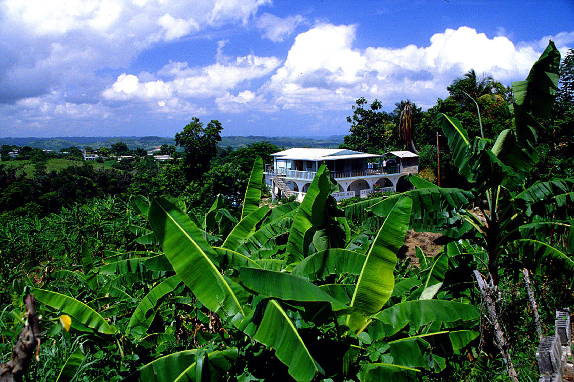
One of the most surprising things about Puerto Rico is how quickly the landscape can change. A short drive can take you from an Atlantic beach to rolling hills, limestone caves, river valleys, or the cooler mountains of the interior. In some parts of the island, you can leave a busy urban area and find yourself surrounded by tropical vegetation within half an hour.
That compact geography is part of what makes Puerto Rico so rewarding to explore. The island may be relatively small, but its landscapes, climates, and communities can feel remarkably different from one region to the next.
Geographic Superlatives and Natural Highlights
Despite its compact size, Puerto Rico contains remarkable geographic extremes, from its highest mountain and longest river to deep canyons, tropical forests, cave systems, and coastal dry forests.
| Feature | Location | Why It Stands Out |
|---|---|---|
| Highest Mountain | Cerro de Punta, between Jayuya and Ponce | The highest point in Puerto Rico, rising approximately 4,390 feet (1,338 meters) above sea level. |
| Longest River | Río de la Plata | Flows approximately 46 miles from the central interior to the Atlantic Ocean near Dorado. |
| Notable Large Reservoir | Lago Dos Bocas, between Arecibo and Utuado | One of Puerto Rico's best-known reservoirs, surrounded by mountain scenery and traditionally visited by boat. |
| Best-Known Rainforest | El Yunque National Forest, northeastern Puerto Rico | The only tropical rainforest in the U.S. National Forest System and one of Puerto Rico's most biologically diverse landscapes. |
| Major Cave and Underground-River System | Río Camuy Cave System, north-central Puerto Rico | An extensive network of limestone caves, sinkholes, and underground passages carved by the Camuy River. |
| Best-Known Coastal Dry Forest | Guánica State Forest, southwestern Puerto Rico | A rare subtropical dry-forest ecosystem containing cactus, drought-resistant vegetation, and numerous endemic species. |
| Tallest Widely Cited Waterfall | Salto La Vaca, Cañón San Cristóbal | A dramatic waterfall estimated at approximately 300 feet; published waterfall heights can vary depending on the method and exact drop being measured. |
| Deepest Land Canyon | Cañón San Cristóbal, between Aibonito and Barranquitas | Carved by the Usabón River and reaching depths of approximately 750 to 800 feet in some areas. |
Why I Love Puerto Rico's Geography?
Growing up on the island, I never realized how unique Puerto Rico's geography was until I moved to the mainland United States. Here, driving several hours may barely change the landscape. In Puerto Rico, a short drive can take you from tropical beaches to cool mountain forests, from dry cactus-covered hills to one of the world's only tropical rainforests managed by the U.S. Forest Service. It's one of the things I appreciate more every time I return home.
Terrain & Topography
Puerto Rico is composed of Jurassic to Eocene volcanic and plutonic rocks, which are overlain by younger Oligocene to recent carbonates and other sedimentary rocks. Most of the caverns and karst topography on the island occurs in the northern Oligocene to recent carbonates. The oldest rocks are approximately 190 million years old (Jurassic) and are located at Sierra Bermeja in the southwest part of the island.
Puerto Rico lies at the boundary between the Caribbean and North American plates. This means that it is currently being deformed by the tectonic stresses caused by the interaction of these plates.
Interesting Fact
70.8% of the world's surface is water, 29.2% is land.
Deep oceans waters fringe Puerto Rico. To the west, the Mona Passage, which separates the island from Hispaniola to the west, is about 80 miles (130 km) wide and more that 3,300 feet (1,000 meters) deep. Off the northern coast in the Atlantic Ocean at the boundary between the Caribbean and North American plates is the Puerto Rico Trench, the largest and deepest trench in the Atlantic. The trench is 800 kilometres (497 mi) long and has a maximum depth of 8,000 metres (26,247 ft) at Milwaukee Deep, which is the deepest point in the Atlantic Ocean. To the south the sea bottom descends to the 16,400 feet (5,000 meters) deep Venezuelan Basin of the Caribbean.
Because of the proximity to the two tectonic plates Puerto Rico experiences an average of five earthquakes (including aftershocks) with a magnitude greater than 1.5 occurring near per day.
Although the vast majority of these earthquakes are too small to be felt by people, but provides evidence that the North American plate is moving westward relative to the Caribbean plate at about two centimeters per year.
Explore Puerto Rico's Topography
Interesting Fact
Puerto Rico is close to the deepest submarine depression in the
North Atlantic Ocean (second in the world). The Puerto Rico Trench, roughly parallel to the
northern coast of the island of Puerto Rico and lying about 75 miles
(120 km) to the north. The Puerto Rico Trench is about 1,090 miles
(1,750 km) long and 60 miles (100 km) wide. The deepest point in the
Atlantic Ocean, the Milwaukee Depth, lies within the Puerto Rico
Trench, at a depth of 27,493 feet (8,380 meters) in the western end of the trench,
about 100 miles (160 km) northwest of Puerto Rico.
The origin of the trench can be traced back to the beginning of the
Tertiary period. The Puerto Rico Trench appears to be part of a
complex system of sinistral strike-slip faults in the north
Caribbean; the trench seems to have been opened continuously for
about 70 million years. It is partially filled with sediments.
The Caribbean's greatest known depth is Cayman Trench (Bartlett Deep) between Cuba and Jamaica, at approximately 25,216 feet (7,686 meters) below sea level.
Terrain & Soil Classification of Puerto Rico
Puerto Rico's diverse landscape results in a variety of soil types, classified differently depending on the approach used.
Different classification schemes exist for the soils of Puerto Rico. One physiographic approach, based on a scientific classification by the U.S. Soil Conservation Service, can be summarized into five general soil types: humid coastal plains, semiarid coastal plains, humid uplands, semiarid uplands, and humid upland valleys. Another classification by soil scientists at the University of Puerto Rico groups the island's soils into coastal lowlands, alluvium, coastal plains, alluvium in terraces, upland dark, and upland reddish-purple.
Agricultural Potential of Puerto Rico's Soils
Although tropical soils are sometimes seen as infertile and poor for agriculture, Puerto Rico's soil diversity has sustained productive farming for centuries. Certain crops thrive in specific soil types due to drainage, moisture retention, and mineral composition.
Best Crops by Soil Type
- Alluvial (Floodplain) Soils – Ideal for: bananas, plantains, yams, taro, and root crops
- Coastal Plains & Lowlands – Used for: coconuts, citrus fruits, mangoes, and pineapples
- Humid Uplands & Valleys – Perfect for: coffee, cacao, and tobacco
- Semiarid Coastal & Upland Soils – Used for: sorghum, legumes, and livestock grazing
Impact of Deforestation & Soil Erosion
Puerto Rico's mountainous terrain and heavy seasonal rainfall make soil erosion a major environmental concern. Over time, deforestation, urbanization, and agricultural expansion have led to:
- Loss of fertile topsoil, affecting crop productivity.
- Increased sedimentation in rivers, impacting water quality.
- Landslides in steep areas, particularly in deforested regions.
To combat these issues, soil conservation efforts such as reforestation programs, contour farming, and terracing are being implemented to preserve the island's agricultural capacity and natural ecosystems.
Regions & Landscape
Mountains
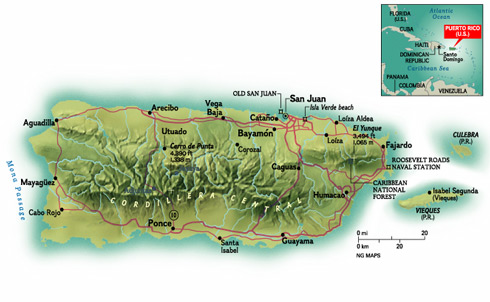
The territory is very mountainous (covering about 60%), except in the regional coasts, but Puerto Rico offers astonishing variety: rain forest, deserts, beaches, caves, oceans and rivers. Puerto Rico has three main physiographic regions: the mountainous interior, the coastal lowlands, and the karst area.
The mountainous interior is formed by a central mountain chain commonly known as the Cordillera Central, extending across the interior of the island, from Mayagüez to Aibonito, which transects the island from east to west. These mountain ranges are La Cordillera Central, La Sierra de Cayey, La Sierra de Luquillo, and La Sierra Bermeja.
Highest Peaks
- Cerro de Punta: 4,390 ft (1,338 m) in Jayuya - Highest point
- Monte Jayuya: 4,314 ft (1,315 m) found between Jayuya and Ciales
- Cerro Rosa: 4,134 ft (1,260 m) in Jayuya
- Piedra Blanca: 4,108 ft (1,252 m)
- Guilarte: 3,953 ft (1,205 m) in Adjuntas
- Tres Picachos: 3,950 ft (1,204 m) in Jayuya
- Maravilla: 3877 ft (1,182 m) in Ponce
Toward to the northeast is Sierra de Luquillo, whose highest peaks are: Toro Hill (1,074 m) found between Río Grande, Naguabo and Las Piedras, and El Yunque Peak (1,065 m) found in Río Grande. Another mountain chain is the Sierra de Luquillo in the northeast.
Coastal Plains
The coastal lowlands extend about 13 to 19 km (8 to 12 mi) inland along the northern coast and 3 to 13 km (2 to 8 mi) along the southern coast. A series of smaller valleys lie perpendicular near the west and east coasts. This region was originally formed by the erosion of the island's interior mountains.
Coastal Features
- North Coast: Atlantic-facing beaches and karst limestone formations
- South Coast: Drier Caribbean-facing coast with mangroves
- East Coast: Palm-lined beaches and El Yunque rainforest
- West Coast: Rugged cliffs and coastal valleys
Karst Region
Another important physiographic feature is the karst region in northern Puerto Rico. This area consists of rugged limestone formations that have been dissolved by water over geological time. The landscape is characterized by extensive mogotes (haystack hills), sinkholes, caves, and limestone cliffs. The karst belt extends from Aguadilla in the west to Loíza just east of San Juan.
Explore Puerto Rico's topographical regions.
Two Different Ways to Explore Puerto Rico
Puerto Rico can be divided in two different ways, depending on what you're exploring.
The tourism regions organize the island into areas that make planning a trip easier, grouping municipalities by attractions, culture, and visitor experiences.
The topographical regions describe Puerto Rico's natural landscapes, including mountain ranges, coastal plains, karst formations, river valleys, wetlands, and forests. These regions explain how the island was formed and why its climate, rivers, wildlife, agriculture, and communities differ from one place to another.
Unique Geological Features
Bioluminescent Bays
Bioluminescent bays, also known as phosphorescent bays, are among the rarest natural wonders in the world. Of the five known year-round bioluminescent bays globally, three are in Puerto Rico—making the island one of the best places on Earth to witness this magical glow.
- Mosquito Bay
Located in Vieques, Mosquito Bay has the highest concentration of dinoflagellates, making its glow the most intense and breathtaking of all bio bays. It holds the Brightest Bioluminescent Bay in the World record (Guinness World Records) - Laguna Grande
Located in Fajardo, this mangrove-surrounded lagoon is easily accessible from San Juan and is a popular choice for kayaking tours. It is Puerto Rico's Only Bioluminescent Lagoon. - La Parguera
Located in Lajas, unlike other bio bays where swimming is restricted, La Parguera allows visitors to swim in the glowing waters. Boat tours and snorkeling experiences are also available.
El Yunque National Forest
El Yunque National Forest is the only tropical rainforest in the U.S. National Forest System, known for its lush landscapes, waterfalls, hiking trails, and rich biodiversity.
Guánica State Forest
Guánica State Forest is one of the world's best-preserved subtropical dry forests, home to unique wildlife, cactus-covered landscapes, and miles of scenic trails along Puerto Rico's southwest coast.
Mona Island
Another unique environment can be found on Mona Island, 50 miles off the west coast of Puerto Rico. Like the Galapagos Islands, this untouched island has species which are not found elsewhere. Mona is a protected island, under the management of the United States National Park Service and the Puerto Rican Natural Resources Department. Accessible by a sometimes difficult, long boat ride, the island is available for sport diving to those who make special arrangements and are willing to rough it out.
The island's geography also creates regional climate variations—from the lush rainforests of El Yunque to the dry coastal environment of Guánica.
Forest Ecosystems
Puerto Rico's forests protect some of the island's most important natural landscapes—from lush tropical rainforests and cool mountain forests to mangroves and dry coastal ecosystems. The most famous is El Yunque National Forest, the only tropical rainforest in the U.S. National Forest System, known for its waterfalls, dense vegetation, and unique wildlife. Together, these protected forests preserve biodiversity, supply fresh water, and offer visitors incredible opportunities to explore nature.
Explore Puerto Rico's forests and nature reserves
Caves and Caverns
Puerto Rico's northern karst region hides one of the most extensive cave systems in the Western Hemisphere. Underground rivers, massive limestone caverns, sinkholes, and ancient Taíno petroglyphs make these caves both natural wonders and historical treasures.
The most famous system is Río Camuy Cave Park, home to one of the world's largest underground rivers and dramatic cathedral-like caverns carved over millions of years.
Explore Puerto Rico's caves and underground landscapes
Rivers, Lakes and Water Systems
Puerto Rico's rivers, reservoirs, and coastal lagoons form an important part of the island's geography. More than 1,200 bodies of water are found across Puerto Rico, with about 50 classified as rivers. Most originate in the island's central mountain range, La Cordillera Central, flowing north toward the Atlantic Ocean or south toward the Caribbean Sea.
While Puerto Rico does not have large natural lakes, the island relies on a network of reservoirs created by damming rivers to provide drinking water, irrigation, and hydroelectric power. Coastal lagoons and wetlands also support important wildlife habitats and marine ecosystems.
Explore Puerto Rico's rivers, reservoirs, and coastal lagoons
Islands & Cays
Puerto Rico's main island is surrounded by dozens of smaller islands, cays, and islets that create some of the Caribbean's most beautiful coastal landscapes. While only a few are inhabited, many are protected as nature reserves, wildlife refuges, or marine ecosystems that are ideal for snorkeling, diving, kayaking, and birdwatching.
Offshore Islands
Puerto Rico has three inhabited offshore islands.
Vieques
Known for its pristine beaches, wild horses, and Mosquito Bay—the world's brightest bioluminescent bay.
Culebra
Home to Flamenco Beach, consistently ranked among the world's best beaches, along with exceptional snorkeling and protected coral reefs.
Mona Island
Often called the "Galápagos of the Caribbean," this remote nature reserve between Puerto Rico and the Dominican Republic is famous for sea caves, cliffs, endemic wildlife, and world-class scuba diving. Access is limited and requires permits.
Smaller Cays
Scattered around Puerto Rico are dozens of tiny coral cays, many reachable only by boat.
Some of the best known include:
- Icacos
- Palomino
- Palominito
- Cayo Luis Peña
- Cayo Aurora (Gilligan's Island)
- Caja de Muertos
- Isla Ratones
These small islands are popular for sailing excursions, snorkeling, paddleboarding, and enjoying crystal-clear shallow waters far from the crowds.
Why So Many Islands?
Puerto Rico sits on a shallow marine platform surrounded by coral reefs, limestone formations, and underwater banks. Over thousands of years, changing sea levels and coral growth created numerous small islands and cays along the coast. Today many are protected by the Puerto Rico Department of Natural and Environmental Resources and the U.S. Fish & Wildlife Service because they provide nesting habitat for sea turtles, seabirds, and fragile coral reef ecosystems.
Interesting Fact
The islands of Cayo Diablo, St. Thomas, St. John, Tortola,
Guana, Greater Camanoe, Necker Cay, and Virgin Gorda
were once known as the Puerto Rico Bank.
Natural Resources & Land Use
- Copper, nickel, iron ore deposits
- Limestone and marble
- Salt from coastal areas
- Clay and sand
- Hydroelectric potential
- Agricultural land: 22%
- Arable land: 6.6%
- Permanent crops: 5.6%
- Permanent pasture: 9.8%
- Forest: 63.2%
- Other: 14.8% (2018 est.)
- El Yunque National Forest
- 19 state forests
- Multiple nature reserves
- Marine protected areas
- Wildlife refuges
Irrigated Land
220 sq km (latest available estimate, 2012)
Natural Hazards:
Periodic droughts; hurricanes
Environment Current Issues
Erosion; occasional drought has
caused water levels in reservoirs to drop and has prompted water rationing.
Many small rivers and high central mountains ensure land is well watered; south coast relatively dry; fertile coastal plain belt in north.
Note: important location along the Mona Passage - a key shipping lane to the Panama Canal; San Juan is one of the biggest and best natural harbors in the Caribbean.
Flora and Fauna
Puerto Rico's diverse landscapes—from tropical rainforests and mountain forests to coastal wetlands and dry forests—support a rich variety of plant and animal life. The island is home to thousands of tropical plant species and unique wildlife, including the famous coquí frog and the endangered Puerto Rican parrot found in the forests of El Yunque.
Discover Puerto Rico's native plants, wildlife, and ecosystems
Climate & Weather
Puerto Rico enjoys a tropical marine climate with warm temperatures year-round and cooling trade winds from the east. Average temperatures range from the mid-70s°F to the upper-80s°F (24–31°C), with wetter months typically occurring from May through October and drier conditions during the winter.
Temperature
Average High: 85°F (29°C)Average Low: 73°F (23 °C)
Rainfall
South Coast: (Driest)30 inchesCoastal: Average60 inches
El Yunque: (Wettest)180+ inches
Hurricane Season
une 1 - November 30 is the official Atlantic hurricane season, with peak activity from August to October.Best Time to Visit
- Winter (Dec-Apr): Peak season, dry and comfortable
- Spring (Apr-May): Great weather, fewer crowds
- Summer (Jun-Aug): Hot, more rain, good for beaches
- Fall (Sep-Nov): Hurricane season, lowest prices
Hurricane Season in Puerto Rico
Hurricanes and tropical storms are part of Puerto Rico's climate, especially during late summer and early fall.
Learn more about Puerto Rico's weather patterns and hurricane season
Time Zone: Atlantic Standard Time (AST), which is one hour later (+1) than Eastern Standard Time (EST) and four hours earlier (-4) than Greenwich Mean Time (GMT). Puerto Rico does not observe Daylight Savings Time.
Atlantic Standard Time (AST, GMT-4, Zone Q), which comprises Puerto Rico and the U.S. Virgin Islands.
The time in Puerto Rico is: 6:0 PM
Sunrise/Sunset Average: 6:54 am to 6:21 pm
Because of the latitude of Puerto Rico the sun is high overhead all year,
there are no great variations from day to day between the times of sunrise and
sunset.
Geography in Everyday Life
Puerto Rico's geography is not simply something seen on a map; it influences how people build homes, grow food, travel, work, and spend time with family.
Homes Shaped by Weather
Concrete homes, storm shutters, flat roofs, cisterns, generators, and elevated structures reflect the realities of tropical storms, intense rainfall, heat, and coastal flooding. In mountainous areas, houses often follow steep slopes, while coastal communities must account for salt air, erosion, storm surge, and strong winds.
Roads That Follow the Land
Travel across Puerto Rico is shaped by mountains, rivers, and the karst landscape. Coastal expressways may be relatively direct, but interior roads frequently climb, curve, and follow ridgelines. A destination that appears close on a map may take longer to reach because the road must wind around mountains or cross narrow valleys.
Agriculture by Elevation
The cooler, wetter highlands historically supported coffee, plantains, citrus, and root crops. Broad coastal plains were better suited to sugar cane, grazing, and large agricultural estates, while drier southern areas developed irrigation systems to support farming.
Communities Built Around Water
Fishing villages developed near protected bays, mangrove lagoons, and river mouths where small boats could be sheltered. Reservoirs and river valleys later influenced where roads, farms, power systems, and population centers expanded.
Climate as Part of Daily Conversation
Puerto Ricans often describe weather by location rather than by the island as a whole. It may be raining in the mountains while the southern coast remains sunny and dry. Someone traveling from San Juan to the interior may bring a jacket, even though the day began hot and humid near the coast.
Food Connected to Place
Regional dishes developed around what could be grown, raised, or caught nearby. Seafood became central to coastal communities, coffee and root vegetables flourished in the mountains, and pork traditions became strongly associated with towns along the central mountain routes.
Geography and Culture
Puerto Rico's regional identities did not develop by accident. The island's mountains, coasts, forests, agricultural valleys, and climate helped shape local occupations, foods, music, celebrations, and recreational traditions.
Central Mountains: Coffee and Lechoneras
The interior's elevation, rainfall, and fertile soil created ideal conditions for coffee cultivation. Towns such as Adjuntas, Jayuya, Lares, Maricao, and Utuado remain closely tied to coffee culture. The mountain roads south of the metropolitan area also became famous for lechoneras, where families gather for roasted pork, music, and long Sunday meals.
Northern Region: Karst, Agriculture, and Dairy Farming
The north combines broad coastal plains with limestone hills, caves, sinkholes, and fertile valleys. These landscapes supported sugar cane, pineapple, cattle, and dairy farming, while the karst region created some of Puerto Rico's most recognizable caves and underground river systems.
Southern Coast: Dry Landscapes and Fishing Traditions
The south receives less rainfall than much of the northern and eastern island. Its dry forests, salt flats, agricultural plains, and protected Caribbean bays encouraged irrigation-based farming, salt production, fishing, and maritime trade. Coastal food traditions emphasize fish, shellfish, and locally prepared fritters.
Western Coast: Surfing and Sunset Culture
The west faces both Atlantic swells and the Mona Passage, creating beaches internationally known for surfing. Towns such as Rincón, Aguadilla, and Isabela developed a strong surf culture, while their western orientation also made sunset gatherings part of the region's identity.
Eastern Region: Rainforests, Mangroves, and Maritime Life
The east is shaped by heavy rainfall, El Yunque, coastal wetlands, marinas, and access to nearby islands and cays. Hiking, boating, snorkeling, fishing, and rainforest excursions are central to both tourism and recreation.
Metropolitan Region: Coast Meets City
San Juan and its surrounding municipalities grew around protected bays, lagoons, ports, and coastal plains. Geography helped make the area Puerto Rico's principal center of commerce and transportation while allowing beaches, mangroves, and urban neighborhoods to exist only minutes apart.
Why I Love Puerto Rico's Regions
After living in the mainland United States, I appreciate even more how Puerto Rico's geography gives each region such a distinct personality. We may all share one island, but the rhythm of a fishing village, a coffee town, a metropolitan neighborhood, and a western surf community can feel completely different.
Other Resources
- Iguana de Mona (Photo source: Iguana)
- 1992 Census of Agriculture [PDF]
- National Weather Service Forecast Office - San Juan, PR
- Puerto Rico Perspectives (Cartographic maps)
- Current Conditions for Puerto Rico
- NOAA/AOML/Hurrican Research Division
- Puerto Rico
- Puerto Rico, Virgin Islands - Latest conditions, forecasts by USA Today
- Puerto Rico Trench
- San Juan Weather Report
Sources:
- Dr. Carr, Gerald (Gerry). Department of Botany and Plant Pathology. Retrieved 2020 from http://www.botany.hawaii.edu/faculty/carr/ (offline). (Photos source: poinciana)
Did You Know?
Puerto Rico's total population continues to shrink slowly from its peak in the early 2000s.
This is your comprehensive guide to La Isla del Encanto.