
Puerto Rico's Topography
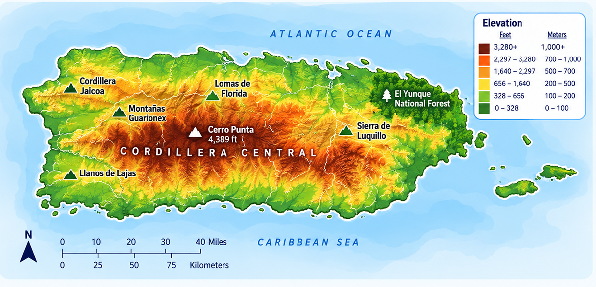
Puerto Rico may cover just 3,515 square miles (9,104 km²), but it contains one of the most geographically diverse landscapes in the Caribbean. Within a relatively short drive, visitors can travel from lush rainforests and rugged mountain peaks to dry forests, limestone caves, mangrove wetlands, and some of the Caribbean's most beautiful beaches. This remarkable variety of landscapes is the result of millions of years of geological activity, tropical weather, and the island's unique location between the Atlantic Ocean and the Caribbean Sea.
| Highest Mountains | |
| Cerro Punta | 4,389 ft |
| Rosa | 4,156 |
| Guilarte | 3,952 |
| Tres Picachos | 3,949 |
| Maravillas | 3,880 |
| Dona Juana | 3,536 |
| Toro | 3,524 |
| Yunque | 3,494 |
| Penuelas | 3,414 |
| Torrecilla | 3,093 |
Understanding Puerto Rico's Landscape
Rather than one continuous landscape, Puerto Rico is divided into several distinct geographic regions that each contribute to the island's beauty and biodiversity.
Puerto Rico's Five Major Landforms
Mountains - The Cordillera Central
Running east to west across the heart of Puerto Rico, the Cordillera Central is the island's backbone. These mountains divide the northern and southern coasts while influencing everything from rainfall and climate to agriculture and transportation.
The range includes Cerro de Punta, Puerto Rico's highest peak at 4,390 feet (1,338 m). The cooler temperatures and fertile soils of these mountains have made them ideal for coffee cultivation for more than two centuries, while scenic winding roads connect picturesque towns such as Jayuya, Adjuntas, Orocovis, and Maricao.
As someone who grew up on the island, one of my favorite drives has always been through the mountains. Every turn seems to reveal another breathtaking valley, hidden waterfall, or roadside café serving locally grown Puerto Rican coffee.
Coastal Plains
Surrounding the mountains are broad coastal plains where most of Puerto Rico's population lives today. These flatter regions became centers for agriculture during Spanish colonial times and later developed into the island's largest cities and transportation hubs.
The northern coastal plain receives significantly more rainfall than the south, while the southern coastal plain is warmer and considerably drier, creating two very different landscapes despite being only a short drive apart.
The Karst Region
Northern Puerto Rico contains one of the world's most important tropical karst landscapes. Millions of years of rainfall slowly dissolved the island's limestone, creating a fascinating terrain filled with caves, sinkholes, underground rivers, and the distinctive rounded hills known as mogotes.
The karst region stretches across municipalities including Arecibo, Camuy, Hatillo, Lares, Florida, and Quebradillas. It is home to spectacular natural attractions such as Río Camuy Cave Park, Cueva Ventana, and numerous protected forests that shelter hundreds of plant and animal species.
Beyond its scenic beauty, this limestone region serves as one of Puerto Rico's largest natural aquifers, supplying groundwater to many communities.
Islands and Cays
Puerto Rico's geography extends well beyond its main island. Offshore islands and cays each possess their own unique ecosystems, beaches, and landscapes.
Notable islands include: Vieques, Culebra, Mona Island, Caja de Muertos and Desecheo Island.
Popular cays include: Icacos, Palomino, Cayo Luis Peña, Cayo Aurora (Gilligan's Island) and Cayo Caracoles.
Many of these smaller islands are protected nature reserves where visitors can enjoy crystal-clear waters, coral reefs, snorkeling, birdwatching, and secluded beaches.
River Valleys
Puerto Rico's rivers have carved broad valleys through the mountains over thousands of years, creating some of the island's most fertile agricultural lands. These valleys became natural corridors for roads, towns, and farming communities, supporting crops such as coffee, plantains, citrus, and vegetables. Many of Puerto Rico's inland municipalities developed along these river systems, which continue to provide drinking water, irrigation, and hydroelectric reservoirs today.
How Puerto Rico Was Formed
Puerto Rico sits near the boundary of the Caribbean and North American tectonic plates. Over millions of years, volcanic activity, tectonic uplift, and erosion gradually shaped the island into its present form.
While ancient volcanoes no longer exist, the mountains that dominate the island today were created as portions of the Earth's crust slowly rose above sea level. Wind, rainfall, and rivers then carved valleys, canyons, caves, and fertile plains that continue to evolve today.
Two Ways to Explore Puerto Rico
Puerto Rico can be explored from two different perspectives, each offering a unique way to discover the island.
Tourism Regions - ideal for planning vacations and road trips.
Topographical Regions - these regions organize Puerto Rico by its natural landscapes—mountain ranges, coastal plains, karst formations, forests, wetlands, and offshore islands.
Coastal Landscapes
Puerto Rico's coastline is far more diverse than many visitors expect. Beyond its beaches, the island is home to mangrove forests, rocky cliffs, coral reefs, sand dunes, salt flats, estuaries, and protected lagoons. These coastal environments help protect the shoreline from storms, support marine life, and create many of the scenic landscapes that define Puerto Rico's coast.
Mangrove Forests
Mangrove forests grow where land meets the sea, forming dense networks of salt-tolerant trees that protect the coastline from erosion and storm surge. Their tangled roots provide nurseries for fish, crabs, shrimp, and countless bird species.
Where to experience them:
- Piñones State Forest
- Boquerón Wildlife Refuge
- Humacao Nature Reserve
- Jobos Bay National Estuarine Research Reserve
Salt Flats
Puerto Rico's salt flats are shallow coastal basins where seawater naturally evaporates, leaving behind mineral-rich salt deposits. For centuries, these areas played an important role in the island's economy and continue to attract photographers, birdwatchers, and nature enthusiasts.
Best known location: Cabo Rojo Salt Flats (Las Salinas de Cabo Rojo)
Coral Reefs
Surrounding much of Puerto Rico are vibrant coral reef ecosystems that shelter hundreds of marine species while helping reduce wave energy before it reaches the shore. These reefs create ideal conditions for snorkeling, diving, and marine conservation.
Popular reef destinations: Culebra, Vieques, La Parguera, Fajardo, and Mona Island.
Beaches
Puerto Rico's beaches vary dramatically from one coast to another. The Atlantic shoreline features stronger waves favored by surfers, while the Caribbean coast is known for calm turquoise waters ideal for swimming. Visitors can also discover black-sand beaches formed by volcanic minerals, brilliant white-sand beaches created from coral and shells, and even the rare red-sand beach on Vieques.
Because of this diversity, no two beach experiences on the island are exactly alike.
Why Puerto Rico Has So Many Different Beaches
One of the biggest surprises for first-time visitors is that Puerto Rico doesn't have just one type of beach. The island's geography, exposure to both the Atlantic Ocean and Caribbean Sea, coral reefs, offshore cays, and diverse coastal ecosystems have created an incredible variety of shorelines. Whether you're looking for powerful surf, calm turquoise waters, secluded coves, or mangrove-lined lagoons, you'll find a beach to match your style.
Atlantic Coast
The beaches along Puerto Rico's north coast face the Atlantic Ocean, where stronger waves and seasonal swells create ideal conditions for surfing, bodyboarding, and dramatic coastal scenery. These beaches tend to have golden sand, limestone cliffs, sea caves, and more active surf.
Best examples: Isabela, Aguadilla, Arecibo, Camuy, and Manatí.
Caribbean Beaches
Along the south and southwest coast, the Caribbean Sea is generally calmer and more protected. The water is often clearer, making these beaches excellent for swimming, snorkeling, paddleboarding, and relaxing with the family.
Best examples: Cabo Rojo, Guánica, Lajas, and Ponce.
White Sand Beaches
Most of Puerto Rico's famous beaches feature brilliant white or cream-colored sand created from crushed coral, shells, and marine organisms over thousands of years.
Best examples: Flamenco Beach, Playa Caracas, Playa Escondida, Playa Buyé, and Seven Seas Beach.
Golden Sand Beaches
Many beaches along the north coast feature soft golden sand formed primarily from quartz and limestone sediments carried by rivers into the Atlantic.
Best examples: Ocean Park, Isla Verde, Luquillo Beach, and Balneario de Dorado.
Black Sand Beaches
Puerto Rico's volcanic history created a handful of black sand beaches where dark volcanic minerals mixed with coastal sediments.
Best examples: Playa Negra (Vieques)
Unlike Hawaii or Iceland, Puerto Rico has only a few black sand beaches, making them especially unique.
Red Sand Beaches
One of Puerto Rico's rarest coastal features is Playa Roja near the Cabo Rojo National Wildlife Refuge.
The beach gets its distinctive reddish hue from tiny particles of iron-rich sediment eroded from the surrounding limestone cliffs and mixed with the sand. The nearby pink salt flats further contribute to the area's striking landscape.
Offshore Islands & Cays
Puerto Rico's nearby islands and cays offer some of the Caribbean's most spectacular beaches. Their shallow reefs protect crystal-clear waters, creating postcard-perfect settings with powdery white sand and exceptional snorkeling.
Best examples: Culebra, Vieques, Icacos, Palomino, and Cayo Aurora (Gilligan's Island).
Mangroves & Lagoons
Not every shoreline is defined by sand. Puerto Rico's mangrove forests, estuaries, and coastal lagoons are vital ecosystems that protect the coastline, support wildlife, and provide peaceful places for kayaking, birdwatching, and nature photography.
Best examples: Piñones, La Parguera, Torrecilla Lagoon, Boquerón, Las Cabezas de San Juan, and Jobos Bay.
Every Beach Has Its Own Personality
Some beaches are known for world-class surfing, while others are perfect for families with young children. You'll also find black volcanic sand, secluded coves, long stretches of golden sand, natural pools, and beaches where sea turtles nest each year. Exploring different regions of Puerto Rico means discovering an entirely different coastal experience every time.
Estuaries
Estuaries are places where rivers meet the ocean, creating nutrient-rich environments that support fish, birds, mangroves, and countless other species. These transitional ecosystems act as natural filters, improve water quality, and provide important breeding grounds for marine life.
Notable estuaries include: San Juan Bay Estuary, Jobos Bay, and Río Espíritu Santo Estuary.
Sea Cliffs
Along portions of Puerto Rico's coastline, waves have carved dramatic limestone and volcanic cliffs that rise directly above the ocean. These rugged landscapes provide breathtaking viewpoints, nesting sites for seabirds, and some of the island's most photographed scenery.
Famous cliff landscapes:
- Cabo Rojo National Wildlife Refuge
- Cueva Ventana area (overlooking the Río Grande de Arecibo valley)
- Survival Beach near Aguadilla
- Guajataca Cliffs (Isabela–Quebradillas)
A Landscape That Never Stops Changing
One of the things I've come to appreciate most after living away from Puerto Rico is how quickly the coastline changes as you travel around the island. In a single day, you can walk through a quiet mangrove forest, snorkel above a coral reef, photograph the pink salt flats of Cabo Rojo, relax on a white-sand Caribbean beach, and finish by watching waves crash against towering sea cliffs on the Atlantic coast. That incredible diversity is one of the reasons Puerto Rico's coastline remains one of its greatest natural treasures—and why no two coastal towns feel exactly the same.
Did You Know?
The term "china" originated from a brand of oranges that came to Puerto Rico in the 19th century, advertised as names "Naranjas de la China/Oranges from China" China in PR is the color orange and the fruit. naranja, which is used for oranges in most Spanish speaking countries, only refers to the bitter orange in Puerto Rico.
Get Our Newsletter
Discover new places, local flavors, upcoming events, cultural stories, and some of our favorite finds from around the island.Read the Latest ¡La Isla! Newsletter
Follow Along


