
Vega Alta, Puerto Rico
(VAI-gah AHL-tah)
Vega Alta is known as "El Pueblo de los Ñangotaos" (town of squaters). Vega Alta is a north-coast municipality where beaches, limestone hills, rivers, and Puerto Rico's agricultural history come together. Founded in 1775 as La Vega Alta de Espinosa by Francisco de los Olivos.
Overview
Why Visit Vega Alta?
Vega Alta offers an appealing combination of beach, nature, history, and everyday Puerto Rican life. Its best-known attraction, Cerro Gordo, combines a beautiful swimming beach with forested hills, camping areas, hiking, and mountain-bike trails.
The municipality is also a good place to explore Puerto Rico beyond the traditional resort experience. Historic sugar-industry landmarks, caves, farms, the Cibuco River, the town plaza, and small local restaurants reveal a community whose history extends far beyond its coastline.
Top Things to Do in Vega Alta
Balneario Cerro Gordo
Vega Alta's signature attraction and one of the most popular family beaches on Puerto Rico's north coast. Rocky headlands help shelter the crescent-shaped beach from the rougher Atlantic surf, creating relatively calm water for swimming. The recreation area includes picnic facilities, showers, camping areas, and access to nearby trails.
Cerro Gordo Mountain Bike Trails
A network of trails climbs through the forested hills overlooking Cerro Gordo. Popular with mountain bikers, runners, and hikers, the trails provide a completely different perspective of the coastline, including dramatic views of cliffs and the Atlantic Ocean.
Playa Tocones
A more natural stretch of Vega Alta's Atlantic coastline where visitors can experience the rugged character of Puerto Rico's north shore away from the facilities of the main balneario.
Galería Lin-Manuel Miranda
A cultural attraction celebrating the work and Puerto Rican roots of playwright and composer Lin-Manuel Miranda, whose family has deep connections to Vega Alta.
Plaza Pública Dr. Gilberto Concepción de Gracia
The traditional heart of Vega Alta, surrounded by civic and religious landmarks. The plaza provides a good starting point for exploring the historic town center.
Iglesia Inmaculada Concepción de María
Vega Alta's historic Catholic church honors the municipality's patroness, the Immaculate Conception. Construction of the original church began in the late 18th century and the structure was developed over subsequent decades.
Chimenea de la Antigua Central Carmen
A surviving reminder of the sugar industry that once played an important role in Vega Alta's economy and the broader economy of Puerto Rico's northern coastal plain.
Cueva de las Golondrinas
One of the natural formations associated with Vega Alta's limestone landscape. The municipality lies within Puerto Rico's northern karst region, an area characterized by caves, sinkholes, and distinctive limestone hills known as mogotes.
Río Cibuco
One of northern Puerto Rico's important rivers, the Cibuco flows through the region before reaching the Atlantic. Historically, the river also helped distinguish the areas that became Vega Alta and neighboring Vega Baja.
Casa del Artesano
Located in Vega Alta's former fire station, the Casa del Artesano provides a space dedicated to local artisans and Puerto Rican craftsmanship.
Plan your Visit
Located on Puerto Rico's north coast about 45 minutes west of San Juan, Vega Alta is easily reached by car and works especially well as a beach or nature day trip.
Getting There
By Air
Luis Muñoz Marín International Airport (SJU) is the closest major airport. Vega Alta is approximately 45 minutes to 1 hour from the airport depending on traffic and your destination within the municipality.
By Car
PR-22 provides the primary highway connection between the San Juan metropolitan area and Vega Alta. PR-2 and local roads provide access to the town center and surrounding communities.
Getting Around
Rental Car
A car is the easiest way to explore Vega Alta. The beach, historic town center, rural communities, restaurants, and natural attractions are spread throughout the municipality.
Walking
The traditional town center can be explored on foot around the plaza, church, and nearby historic buildings.
Cerro Gordo
Once inside the recreation area, visitors can explore the beach on foot or follow trails into the surrounding hills. Mountain biking is also popular here.
Taxis & Rideshare
Service may be available, particularly closer to Dorado and the metropolitan area, but it is less dependable for exploring rural and coastal areas. Renting a car is recommended.
Nature & Resources
Geography
Vega Alta stretches from the Atlantic Ocean southward into Puerto Rico's northern limestone region. The northern portion forms part of the Northern Coastal Plain, while the landscape becomes hillier toward the south, north of Morovis and Corozal; east of Vega Baja; and west of Dorado.
Much of the municipality also lies within Puerto Rico's northern karst zone. This geology creates distinctive mogotes, caves, sinkholes, underground drainage systems, and limestone formations. Elevations increase toward the southern part of Vega Alta, particularly around Cienegueta.
Rivers
The Río Cibuco is the principal river associated with Vega Alta and one of the important waterways of Puerto Rico's north-central region. Its watershed helped shape the fertile lands that historically supported agriculture in the area.
The Cibuco is also connected to the names of Vega Alta and Vega Baja. Historically, the two communities developed on opposite areas of the river valley, with Vega Alta occupying the slightly higher ground.
Coastline
Vega Alta's Atlantic shoreline alternates between sandy beaches, rocky headlands, and coastal vegetation. Cerro Gordo is unusual along the often-rough north coast because surrounding rock formations help shelter portions of the beach, creating calmer swimming conditions.
Neighborhoods & Barrios
Vega Alta is made up of 8 barrios (PDF) (wards/districts):
- Bajura
- Candelaria
- Cienagueta
- Espinosa
- Maricao
- Mavilla
- Pueblo
- Sabana
Climate
Vega Alta has a warm tropical climate throughout the year. Daytime temperatures are generally warm to hot, with somewhat cooler conditions in the evening and in the hillier southern areas of the municipality.
The wetter season generally extends from late spring through fall, while winter and early spring tend to bring somewhat drier conditions. Brief tropical showers can occur at any time of year.
Along the Atlantic coast, ocean conditions can change considerably with weather and seasonal swells. Cerro Gordo is more protected than many north-coast beaches, but visitors should always pay attention to posted warnings and current water conditions before swimming.
10 Day Forecast from weather.com
Where to Stay
Vega Alta has a smaller lodging scene than neighboring Dorado, but visitors can find vacation rentals and coastal accommodations near Cerro Gordo. A much larger selection of hotels and resorts is available just minutes away in Dorado.
- Casa Cerro Gordo
- Casa Azul Cerro Gordo
- Blue Lagoon Apartments
- El Dorado Beach House
- Coconut Beach Club Apartments
- Lakeside Villas
- Villa Oleana
- Villa Iris
- Villa Yari
- Villa Joselí
- Hyatt Vacation Club at Hacienda del Mar
- Embassy Suites by Hilton Dorado del Mar Beach Resort
- Viento Beach Lodge
Local Flavors & Festivities
Vega Alta's food scene is casual and distinctly local. Seafood, mofongo, roasted meats, tripletas, bakeries, and Puerto Rican comfort food dominate, with many popular restaurants located along PR-2 and the roads leading toward Cerro Gordo.
Where to Eat
- El Tablado de la 2
- Cosechando Bar & Grill
- Junior's Place & Seas Food
- Pico Rico's BBQ
- El Veril
- El Niño Seafood
- Junior's Place & Seas Food
- El Gallo Tripletero
- Las Papas Locas
- Charlie's Burger
- La Pizzelta
- Momentos Café Coffee Shop & Bistro
- Dream Coffee
- Pan Factory Bakery
Festivals and Events
Displaying 13 results.
-
Fiesta de Reyes y Octavitas
- January
Traditional Three Kings and Octavitas celebrations held throughout Vega Alta, continuing Puerto Rico's extended Christmas season with music, community gatherings, and local traditions.
-
Carnaval Vegalteño
- February
Annual carnival held around Vega Alta's public plaza featuring colorful parades, music, costumes, food, artisans, and community festivities. The Carnaval Vegalteño was established in 1984 and has become one of the municipality's signature celebrations.
-
Fiesta de la Candelaria
- February
Traditional celebration of Candlemas held in the Espinosa barrio, reflecting one of Vega Alta's long-standing community and religious traditions.
-
Festival de la Chiringa
- April
Community kite festival celebrating the Puerto Rican tradition of flying chiringas, with family activities and outdoor recreation.
-
Festival del Coco
- July
Festival held in Cerro Gordo celebrating coconut and the coastal traditions of Vega Alta with food, music, and community activities.
-
Festival del Juey
- July
Community food festival held in the Breñas area celebrating jueyes, or land crabs, and the coastal culinary traditions of northern Puerto Rico.
-
Festival del Panapén
- July
Festival held in the Sabana Hoyos community celebrating breadfruit, or panapén, with traditional foods, local music, community activities, and Puerto Rican culture.
-
Paseo de la Virgen del Carmen
- July
Traditional celebration honoring the Virgen del Carmen at Balneario Cerro Gordo, connecting Vega Alta's Catholic traditions with its coastal community.
-
Torneo de la Amistad
- July
Annual friendship tournament held at Balneario Cerro Gordo as part of the municipality's summer recreational activities.
-
Festival del Gallo
- October
Traditional community festival held in Barrio Maricao featuring local culture, music, food, and entertainment.
-
Festival de la Guitarra
- December
Music festival held in Vega Alta's public plaza celebrating the guitar and Puerto Rico's musical traditions through live performances.
-
Fiestas de Pueblo
- December
Annual town celebration held during the Christmas season with live music, food, artisans, entertainment, and community activities.
-
Fiestas Patronales de la Inmaculada Concepción
- December
Traditional patron saint festivities honoring the Inmaculada Concepción, patroness of Vega Alta, with religious observances, music, food, community activities, and celebrations in the town center.
History
Moments in History
The lands that became Vega Alta were settled before the municipality was formally established. The fertile northern coastal plain supported agriculture, while rivers, forests, and access to the Atlantic shaped the development of the surrounding communities.
Vega Alta was founded on June 19, 1775 by Francisco de los Olivos. The community was initially known simply as Vega and later as La Vega Alta de Espinosa. Neighboring Vega Baja was established the following year.
Agriculture became central to Vega Alta's development. Sugarcane, coffee, fruits, and smaller crops were cultivated in the fertile lands of the municipality. Sugar eventually became particularly important, leaving landmarks such as the chimney of the former Central Carmen as reminders of the area's agricultural and industrial past.
On October 12, 1898, during the transition from Spanish to United States rule following the Spanish-American War, Vega Alta's mayor received American troops and the United States flag was raised at the municipal government building.
Vega Alta temporarily lost its municipal independence in 1902 when it was annexed to neighboring Vega Baja. The arrangement was reversed in 1905, restoring Vega Alta as an independent municipality.
During the 20th century, improved roads and the expansion of Puerto Rico's metropolitan region gradually transformed Vega Alta. Agriculture declined in importance while residential development, commerce, manufacturing, services, and tourism became increasingly significant.
Today, Vega Alta combines its historic town center and agricultural heritage with growing residential communities and one of the north coast's most popular recreational areas at Cerro Gordo.
Moments in History
Vega Alta is founded on June 19 by Francisco de los Olivos and develops as La Vega Alta de Espinosa.
Construction begins on Vega Alta's Catholic church dedicated to the Inmaculada Concepción, the municipality's patroness.
On October 12, Vega Alta's municipal government receives United States troops during the political transition following the Spanish-American War.
Vega Alta loses its status as an independent municipality and is annexed to neighboring Vega Baja.
Vega Alta regains its municipal independence.
The Centro Cultural de Vega Alta is established, helping preserve and promote the municipality's history and cultural traditions.
Vega Alta balances its historic agricultural identity with residential growth, commerce, outdoor recreation, and tourism centered around Cerro Gordo and Puerto Rico's north coast.
Notable People
Vega Alta has produced influential musicians, athletes, educators, political leaders, and cultural figures. The municipality also maintains strong ties to the Miranda family, whose connection to Vega Alta has brought international attention to the town.
Famous Vegalteños
Ladislao "Maestro Ladí" Martínez Otero
1898–1979
Music & Culture
Influential Puerto Rican cuatro player, composer, and bandleader who helped shape the development of traditional Puerto Rican music during the 20th century. Known as "Maestro Ladí," he remains one of Vega Alta's most celebrated musical figures.
Gilberto Concepción de Gracia
1909–1968
Law & Politics
Attorney and political leader best known as the founder of the Puerto Rican Independence Party (PIP). He became one of the most prominent advocates for Puerto Rican independence during the 20th century.
Bernie Williams
1968–
Baseball & Music
Former New York Yankees center fielder and accomplished guitarist. Williams grew up with strong roots in Vega Alta's Maricao community and became one of Puerto Rico's most successful Major League Baseball players.
Pedro Nazario Laureano de la Vega y Montilla
1838–1888
Education & Civic Leadership
Born in Vega Alta, he served as mayor and became an important educator and civic leader. He freed 31 enslaved people inherited from his father and later founded the Sociedad Protectora de la Inteligencia to help talented students with limited financial resources pursue their education.
Benjamín Negrón Rodríguez
1939–
History & Education
Educator, writer, researcher, and longtime chronicler of Vega Alta's history. In 2007, the municipal legislature formally recognized him as the Official Historian of Vega Alta, honoring decades of work preserving the municipality's stories, photographs, and cultural heritage.
Lin-Manuel Miranda
1980–
Theater & Music
Puerto Rican-American playwright, composer, actor, and creator of Hamilton and In the Heights. Although born in New York City, Miranda's family comes from Vega Alta, where he spent summers and Christmas holidays growing up. His continuing relationship with the town includes the Lin-Manuel Miranda Gallery in Vega Alta's historic center.
City Symbols
Vega Alta's municipal symbols reflect the town's religious heritage, agricultural past, and history. The Inmaculada Concepción, founder Francisco de los Olivos, and the sugarcane industry that once shaped the municipality are all represented in its official emblems.
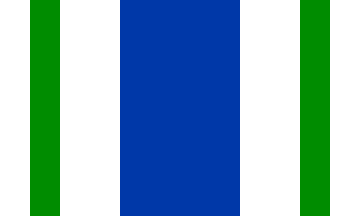
Flag
Vega Alta's flag is based on the colors and symbolism of the municipal coat of arms. It consists of seven vertical stripes arranged in white, green, white, blue, white, green, and white, with the central blue stripe considerably wider than the others.
The blue represents the Inmaculada Concepción de María, Vega Alta's patroness, while white symbolizes purity. Green recalls the olive branches represented on the coat of arms and the municipality's founder, Francisco de los Olivos.
Coat of Arms
The coat of arms features a broad blue vertical band containing a silver vase from which a branch of lilies emerges. The vase and lilies symbolize the Virgin Mary under the title of the Inmaculada Concepción, patroness of Vega Alta.
Olive branches on either side commemorate the municipality's founder, Francisco de los Olivos. Sugarcane branches surrounding the shield recall Vega Alta's history as part of Puerto Rico's once-important sugar-producing region.
Above the shield is a gold mural crown with three towers, the traditional heraldic symbol identifying Vega Alta as a municipality.
Anthem
Vega Alta's municipal anthem was composed by Domingo "Juniquín" Figueroa Ramírez, with a musical arrangement by José Emilio Pizarro. It was officially approved on January 11, 2000.
En la costa norte de mi islita...
Nicknames
Vega Alta is traditionally known as El Pueblo de los Ñangotaos. According to local history, the nickname comes from the custom of jíbaros squatting — ñangotarse — around the plaza or railroad station while waiting for the train.
Human & Capital Resources
Economy
Vega Alta's economy has changed considerably over its history. Agriculture and livestock were among the earliest economic activities in the region, with farmers producing rice, corn, coffee, fruits, and other crops. During the 19th and early 20th centuries, sugarcane became increasingly important, particularly in the flatter northern portions of the municipality.
For much of the early 20th century, Central Carmen played an important role in Vega Alta's economy and provided employment for generations of local residents. Sugarcane remained one of the municipality's principal sources of employment until the decline and eventual closure of Central Carmen and nearby Central San Vicente.
As the sugar industry disappeared, manufacturing became increasingly important. Factories established through Puerto Rico's industrialization programs produced plastics, electrical products, automobile components, bottles, pharmaceuticals, clothing, textiles, and other manufactured goods.
Today, Vega Alta has a more diversified economy centered on services, retail, manufacturing, health care, government employment, construction, and small businesses. Commercial activity is concentrated along major transportation corridors such as PR-2 and in the traditional urban center.
Tourism and recreation also contribute to the local economy. Balneario Cerro Gordo attracts visitors from throughout Puerto Rico, supporting restaurants, vacation rentals, recreational businesses, and other services along the coastal communities of Sabana and nearby Dorado.
Vega Alta reflects one of the major economic transformations experienced across Puerto Rico. A municipality once heavily dependent on agriculture and sugarcane gradually transitioned toward manufacturing and today relies increasingly on services, commerce, health care, tourism, and other industries.
Education
Public education in Vega Alta is administered primarily by the Puerto Rico Department of Education. The municipality has elementary, intermediate, and high schools serving communities throughout Vega Alta, along with private and bilingual educational options.
Education in Vega Alta has changed dramatically since the municipality's early history. In 1854, historical records indicate that the town had a school serving only 24 students. By 1897, Vega Alta had five schools and 178 students, including schools in the town center and the barrios of Maricao, Bajura, and Cienegueta.
The public school system expanded rapidly during the 20th century. By 1918, Vega Alta had schools operating in every barrio, with approximately 1,019 students and 20 teachers.
Today, schools listed by the municipality include Elemental Urbana, Ignacio Miranda, Antonio Paoli, Rafael Hernández Marín, Elisa Dávila Vázquez, José M. Pagán de Jesús, Francisco Felicié Martínez, Apolo San Antonio, Ileana de Gracia, and Ladislao Martínez Otero (Maestro Ladí).
Private education is also available through institutions such as Academia Discípulos de Cristo and NW Bilingual Academy.
Among Vega Alta residents age 25 and older, approximately 80.7% have completed high school or higher, while 25.7% hold a bachelor's degree or higher.
Demographics *
Population
35,395
Land Area: 27.73 sq mi
Density: 1,318.50 per sq mi
Median Age: 40.2
Sex: 52% female
Economics **
$13,439
Median household income: $20,809
Puerto Rico: $21,058
Persons below poverty line: 45.3%
Housing, families and educational attainment *
Number of households
12,124
Housing units density:
613.1 (2013)
Persons per household: 2.98
High school grad or higher: 74%
Marital status: 45% married
* U.S. Census Bureau 2020 data, unless otherwise noted - Source: Quick Facts Puerto Rico.
** U.S. Census Bureau 2016-2020
Map References
Coordinates: 18.4122° N, 66.3314° W
ZIP Code: 692
Driving Distance from San Juan: 27.9 miles
Driving Time: 46 minutes
Frequently Asked Questions
Where is Vega Alta located?
Vega Alta is located on Puerto Rico's northern coast, west of Dorado and east of Vega Baja. It is approximately 30 miles west of San Juan and about a 45-minute drive from the capital, depending on traffic.
What is Vega Alta known for?
Vega Alta is best known for Balneario Cerro Gordo, its north-coast beaches, limestone karst landscape, mountain-bike trails, and its history as an agricultural and sugar-producing municipality.
What is the best beach in Vega Alta?
Balneario Cerro Gordo is Vega Alta's best-known beach. Rocky headlands help shelter portions of the shoreline, making it popular for swimming, picnicking, camping, and family outings.
How far is Vega Alta from San Juan?
Vega Alta is approximately 30 miles west of San Juan. Driving generally takes around 45 minutes to one hour, depending on traffic and your destination within the municipality.
Is Vega Alta worth visiting?
Yes. Vega Alta is a good choice for travelers interested in beaches, outdoor recreation, local food, Puerto Rican history, and a quieter north-coast experience within easy reach of San Juan and Dorado.
Can you camp at Cerro Gordo?
Yes. The Cerro Gordo recreation area includes designated camping facilities near the beach. Reservations and applicable permits should be confirmed before planning an overnight stay.
Can you hike or mountain bike in Vega Alta?
Yes. The hills surrounding Cerro Gordo contain a popular network of trails used for mountain biking, hiking, running, and exploring the coastal landscape.
Does Vega Alta have caves?
Yes. Vega Alta lies within Puerto Rico's northern karst region, a limestone landscape characterized by caves, sinkholes, underground drainage, and distinctive hills known as mogotes.
What does "El Pueblo de los Ñangotaos" mean?
Vega Alta is traditionally known as El Pueblo de los Ñangotaos. According to local history, the nickname comes from the custom of jíbaros squatting around the town plaza or railroad station while waiting for the train.
What are the barrios of Vega Alta?
Vega Alta consists of seven barrios — Bajura, Candelaria, Cienegueta, Espinosa, Maricao, Mavilla, and Sabana — plus Vega Alta barrio-pueblo, the traditional urban center.
When was Vega Alta founded?
Vega Alta was founded on June 19, 1775 by Francisco de los Olivos. The community was historically known as Vega and later as La Vega de Espinosa.
What is the difference between Vega Alta and Vega Baja?
Vega Alta and Vega Baja are neighboring but separate municipalities. Vega Alta was founded in 1775, while Vega Baja was founded the following year. Their names reflect the historic division of the larger area once known as Las Vegas.
Did You Know?
Over 40% of the population lives in poverty, according to 2016 Census estimates.
Get Our Newsletter
Discover new places, local flavors, upcoming events, cultural stories, and some of our favorite finds from around the island.Read the Latest ¡La Isla! Newsletter
Follow Along


